The Growing Crisis of Continental Drying
The planet is currently facing an unprecedented loss of freshwater, a phenomenon often referred to as “continental drying.” According to a 2025 World Bank report, an estimated 324 trillion liters (equivalent to 85.6 trillion gallons) of freshwater vanish annually. This colossal volume is enough to sustain approximately 280 million people for a year. The primary drivers behind this persistent decline are intensifying droughts and unsustainable land and water management practices across the globe. In an effort to raise global awareness about the escalating issues of desertification and drought, and to encourage restorative actions for degraded lands, the United Nations observes June 17 as the World Day to Combat Desertification and Drought. This report delves into ten stark examples, revealed through satellite imagery, of shrinking lakes, rivers, and dams that underscore the severity of this global crisis.
Paraná River, Argentina
The Paraná River, South America's second-longest river stretching approximately 4,900 kilometers (3,030 miles), is a vital commercial conduit linking Brazil, Paraguay, and Argentina. Satellite images from 1990 contrasted with those from 2026 illustrate a severe reduction in water levels, particularly at the port of Rosario. This drastic shrinkage, exacerbated by multi-year droughts, has significantly hampered grain shipping, diminished hydroelectric power generation at the Itaipu Dam, and exposed extensive riverbed areas, leading to the formation of new islands.
Lake Poopó, Bolivia
Located at an elevation of 3,700 meters (12,000 feet), Lake Poopó in Bolivia stands as one of the most extreme instances of a disappearing high-altitude lake. Once Bolivia's second-largest lake, covering about 1,000 square kilometers (390 square miles), satellite imagery comparing 1984 and 2020 shows its near-total disappearance. Water diversion for agricultural use, prolonged drought, and rising temperatures have largely transformed it into a salt flat, devastating local fisheries and the traditional livelihoods of the Indigenous Uru communities.
Lake Ngami, Botswana
Situated at the southwestern periphery of Botswana's Okavango Delta, Lake Ngami is characterized by extreme fluctuations, oscillating between a thriving wetland and near-desiccation. Satellite images from 1984 and 2020 vividly demonstrate its highly variable and climate-sensitive nature. Driven by severe droughts and inconsistent inflows from upstream channels, the lake almost completely vanished at its lowest point, turning productive fishing grounds and livestock pastures into a parched, cracked basin, before experiencing a period of partial recovery.
Laguna de Aculeo, Chile
Near Santiago in Paine, Chile, the Aculeo Lagoon offers a striking example of a lake that has disappeared within recent decades. Satellite imagery from 2007 and 2026 reveals how this once-popular recreational destination, which supported local communities, has largely dried up, a consequence of prolonged drought and intense water stress.
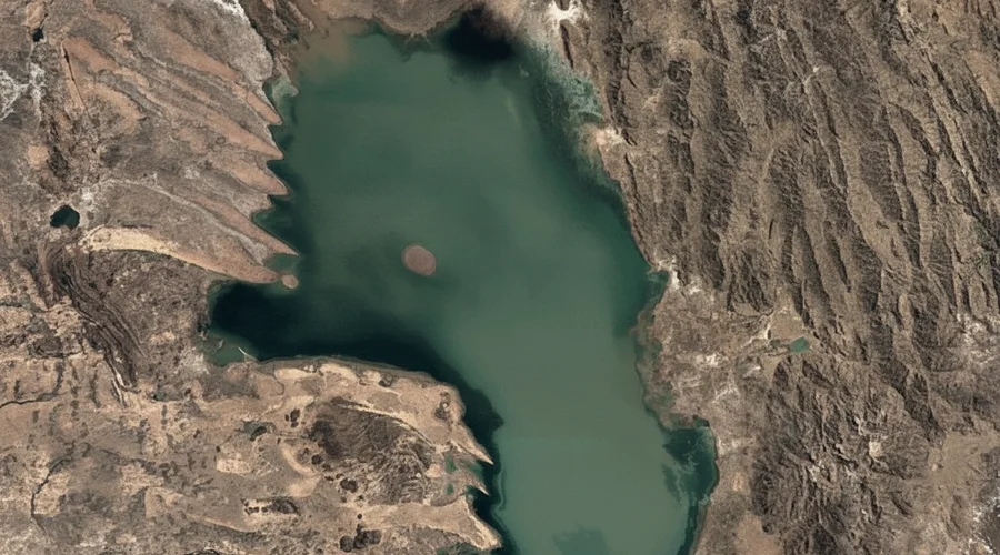
Lake Urmia, Iran
In northwestern Iran, Lake Urmia was formerly the Middle East’s largest saltwater lake, spanning nearly 6,000 square kilometers (2,300 square miles) in the 1990s. Today, its size has plummeted to approximately 581 square kilometers (224 square miles), representing less than 10 percent of its original expanse. A combination of successive droughts, extensive agricultural water consumption, river diversions, and groundwater extraction has converted vast areas of Lake Urmia into exposed salt flats.
The Al-Chibayish Marshes, Iraq
The Al-Chibayish Marshes in southern Iraq are an integral part of the broader Mesopotamian Wetlands, a UNESCO World Heritage Site nourished by the Tigris and Euphrates rivers. These marshes are recognized as one of the Middle East's most crucial wetland ecosystems. Satellite comparisons from 1984 and 2020 depict significant alterations. Severe drainage and drought in the 1990s led to widespread drying, though some areas have shown signs of recovery in recent years due to increased rainfall and ongoing restoration efforts.
Ambovombe, Madagascar
Ambovombe, a town in southern Madagascar, lies within one of the country's most climate-vulnerable and drought-prone regions. Satellite images from 1985 and 2020 underscore a profound ecological crisis affecting southern Madagascar, driven by multi-year drought and escalating temperatures. Intense red sandstorms and a deficit in rainfall have degraded vital water sources and farmlands, severely impacting subsistence agriculture and livestock, thereby contributing to widespread hardship and population displacement.
Lake Faguibine, Mali
Located near the edge of the Sahara Desert in northern Mali, Lake Faguibine has largely disappeared over recent decades. Historically replenished by floodwaters from the Niger River, satellite images from 1984 to 2020 illustrate how reduced flooding, persistent drought, and sediment accumulation have caused the lake to shrink dramatically, leaving much of its basin dry and increasingly desertified.
Lake Mead, United States
Situated on the Nevada-Arizona border, Lake Mead holds the distinction of being the largest reservoir in the United States by capacity. Created by the construction of the Hoover Dam on the Colorado River in the 1930s, it serves as an indispensable water source for millions across the US Southwest and parts of Mexico. Satellite imagery comparing 1984 and 2020 reveals the reservoir's alarming decline, as prolonged drought, rising temperatures, and substantial water demand have caused water levels to fall sharply, exposing vast expanses of shoreline and previously submerged land.
South Aral Sea, Uzbekistan
The South Aral Sea in northwestern Uzbekistan is a stark symbol of one of the world's most severe human-induced environmental catastrophes. Satellite images from 1984 and 2020 vividly document the lake's dramatic disappearance. Decades of river diversions for irrigation purposes have led to an environmental disaster of immense scale, shrinking the sea by over 90 percent and exposing vast stretches of its former seabed.
Source: Al Jazeera
Related Articles
 world
world
Escalating Tensions: Israeli Actions in Lebanon Jeopardize US-Iran Agreement
 world
world
G7 Leaders Pledge Enhanced Support for Ukraine and Stricter Sanctions on Russia
 world
world
Iranian Oil Tankers Depart Blockade Zone Ahead of US-Iran Peace Negotiations
 world
world